搜索结果: 1-15 共查到“工学 Tropical”相关记录84条 . 查询时间(1.234 秒)

中国地质大学科学技术发展院顾延生* 等,环境学院, Climate Dynamics (2020), ENSO-related droughts and ISM variations during the last millennium in tropical southwest China(图)
中国西南热带地区;印度夏季风(ISM);演化;干旱发生;太阳活动;ENSO驱动机制
2021/10/15
近日,中国地质大学环境学院顾延生教授团队题为《中国西南热带地区过去千年来ENSO关联的干旱与印度夏季风变化》(ENSO-related droughts and ISM variations during the last millennium in tropical southwest China)的学术论文刊发在杂志《Climate Dynamics》上,该文为深刻理解中国西南热带地区印度夏季...
第三届热带和亚热带遥感应用国际会议(3rd International Conference on Remote Sensing Applications in Tropical and Subtropical Areas)
第三届 热带和亚热带遥感应用 国际会议
2017/7/18
The 2nd Conference of the Digital Belt and Road (DBAR 2017) and the 3rd International Conference on Remote Sensing Applications in Tropical and Subtropical Areas (RSATSA 2017) will be held in Hong Kon...
LIGHT DIFFUSION IN THE TROPICAL DRY FOREST OF COSTA RICA
Leaf area index spectral vegetation indices MODIS
2016/11/30
Leaf Area Index (LAI) has been defined as the total leaf area (one-sided) in relation to the ground. LAI has an impact on tree growth and recruitment through the interception of light, which in turn a...
ON-LINE CHANGE MONITORING WITH TRANSFORMED MULTI-SPECTRAL TIME SERIES,A STUDY CASE IN TROPICAL FOREST
Multi-Spectral BFAST Dimension Reduction Deforestation Monitor
2016/11/24
In recent years, the methods for detecting structural changes in time series have been adapted for forest disturbance monitoring using satellite data. The BFAST (Breaks For Additive Season and Trend) ...
MAPPING TROPICAL FOREST FOR SUSTAINABLE MANAGEMENT USING SPOT 5 SATELLITE IMAGE
SPOT 5 tropical forest stand volume supervised classification unsupervised classification
2016/11/23
This paper describes the combination of multi-data in stratifying the natural evergreen broadleaved tropical forest of the Central Highlands of Vietnam. The forests were stratified using both unsuperv...
CLOUD AND CLOUD SHADOW MASKING USING MULTI-TEMPORAL CLOUD MASKING ALGORITHM IN TROPICAL ENVIRONMENTAL
Multitemporal Cloud Masking Algrithm Cloud Cloud Shadow
2016/7/8
A cloud masking approach based on multi-temporal satellite images is proposed. The basic idea of this approach is to detect cloud and cloud shadow by using the difference reflectance values between cl...

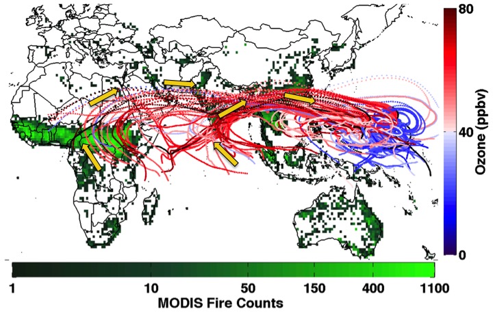
Fires Burning in Africa & Asia Cause High Ozone in Tropical Pacific(图)
Fires Burning Africa Asia High Ozone Tropical Pacific
2016/1/22
While efforts to limit ozone precursor emissions tend to focus on industrial activities and fossil fuel combustion in the United States and China, a new University of Maryland-led study suggests that ...
LOCAL SCALE MAPPING OF NET PRIMARY PRODUCTION IN TROPICAL RAIN FOREST USING MODIS SATELLITE DATA
Local scale Mapping Net Primary Production MODIS Tropical Rain Forest
2016/1/3
Satellite data from Moderate Resolution Imaging Radiometer (MODIS) is currently being used to extract net primary production (NPP) at global scale. Over the years, small scale on-ground flux tower mea...
ASSESSMENT OF IMPACT ON LANDSCAPE DEVELOPMENT TO ECOLOGICAL SERVICE VALUES AND GOODS IN MALAYSIA LOWLAND TROPICAL RAINFOREST USING INTEGRATED REMOTE SENSING AND GIS TECHNIQUES
landscape mapping rapid assessment tropical rain forest Remote Sensing GIS sustainability environmental change
2016/1/3
Amongst the impacts of converting forest to agricultural activities is the degradation of ecology service values and goods (ESVG). Impacts on ESVG can be devastating in environmental,biological, and s...
ALOS PALSAR DATA FOR TROPICAL FOREST INTERPRETATION AND MAPPING
Vegetation Interpretation Land-cover Landuse Mapping SAR
2015/12/30
Tropical forest cover is changing in many parts of the World and got attention to the global community since it is one of the main drivers of climate change. Microwave sensor data is useful to monitor...
LAND COVER CLASSIFICATION USING MULTI-SOURCE DATA FUSION OF ENVISAT-ASAR AND IRS P6 LISS-III SATELLITE DATA–A CASE STUDY OVER TROPICAL MOIST DECIDUOUS FORESTED REGIONS OF KARNATAKA,INDIA
Remote sensing Land cover Classification Multisensor Fusion ASAR
2015/12/23
The present study addresses the potential of Synthetic Aperture Radar (SAR) data for land cover classification in parts of Dandeli forested regions, Karnataka, India. a FCC has been generated from coh...
Model Tropical Legume Trees for Reversing Soil Degradation as a Solution for Increasing Rural Farmers Income by GIS Analysis
Photogrammetry GIS Agriculture Crop Soil Developing Countries Change Detection Prediction
2015/12/2
Poverty in rural areas of developing countries is one of the major global issues. Economic growth in rural areas of Sri Lanka has been significantly lower than in the urban areas, especially around Co...
Importance of the lilac-crowned parrot in pre-dispersal seed predation of Astronium graveolens in a Mexican tropical dry forest
Amazona fi nschi Chamela-Cuixmala fruit crop size granivory
2015/11/13
Parrots represent a large biomass of canopy granivores in tropical forests, and may be effective pre-dispersal
seed predators. We evaluated the importance of the lilac-crowned parrot (Amazona fi...
GEOSTATISTICAL TEXTURE CLASSIFICATION OF TROPICAL RAINFOREST IN INDONESIA
spectral classification tropical rainforests semivariogram texture layers geostatistics
2015/9/28
Traditional spectral classification of remote sensing data applied on per pixel basis ignores the potentially useful spatial information between the values of proximate pixels. Although spatial inform...
ON THE USE OF SHORTWAVE INFRARED FOR TREE SPECIES DISCRIMINATION IN TROPICAL SEMIDECIDUOUS FOREST
SHORTWAVE INFRARED TREE SPECIES DISCRIMINATION TROPICAL SEMI DECIDUOUS FOREST
2015/9/21
Tree species mapping in tropical forests provides valuable insights for forest managers. Keystone species can be located for collection of seeds for forest restoration, reducing fieldwork costs. Howev...

