搜索结果: 1-15 共查到“摄影测量与遥感技术 Environment”相关记录95条 . 查询时间(0.171 秒)

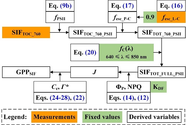
Remote Sensing of Environment刊发中国科学院水利部水土保持研究所吕肖良研究员团队日光诱导叶绿素荧光研究工作进展(图)
吕肖良 日光诱导 叶绿素荧光 SIF GPP
2022/6/8

同济大学测绘与地理信息学院王群明教授课题组本科生在遥感领域顶级期刊《Remote Sensing of Environment》发表论文:Blocks-removed spatial unmixing for downscaling MODIS images(图)
同济大学 测绘与地理信息学院 王群明 教授 课题组 遥感领域 顶级期刊
2021/3/18
近日,同济大学测绘与地理信息学院王群明教授课题组在遥感领域顶级期刊《Remote Sensing of Environment》发表了1篇论文。本研究受到国家自然基金项目(41971297)资助。
中国南极测绘研究中心庞小平教授团队海冰遥感研究成果在《Remote Sensing of Environment》发表
中国南极测绘研究中心 庞小平 教授 海冰遥感 研究成果 《Remote Sensing of Environment》
2020/9/7
通过更高分辨率的热红外影像,我们能发现北极海冰的哪些有趣特性?近日,我中心博士生范沛为第一作者,赵羲副教授为通讯作者的研究论文在《环境遥感》发表。该研究基于Landsat 8 TIRS热红外影像,验证了几种经典的温度反演算法在北极海冰区域的精度,并对冰间水道和海冰边缘带的温度特征进行了分析。
LANDSLIDE HAZARD ZONATION MAPPING OF CHAMOLI LANDSLIDES IN REMOTE SENSING AND GIS ENVIRONMENT
Landslides Chamoli Remote Sensing Hazard, Himalaya
2019/2/27
Landslides are very common problem in hilly terrain. Chamoli region of Himalaya is highest sensitive zone of the landslide hazards. The purpose of Chamoli landslide study, to observe the important ter...
ORTHORECTIFICATION OF A LARGE DATASET OF HISTORICAL AERIAL IMAGES: PROCEDURE AND PRECISION ASSESSMENT IN AN OPEN SOURCE ENVIRONMENT
image orthorectification GIS historical aerial images
2018/11/8
The availability of data time series spanning a long period is crucial for landscape change analysis. A suitable dataset, both in terms of time span and information content, must be available for the ...

电子科技大学资源与环境学院博士生在Remote Sensing of Environment发表论文(图)
电子科技大学资源与环境学院 博士生 Remote Sensing of Environment 微波遥感
2018/4/12
近日,资源与环境学院定量遥感团队博士生廖展芒在遥感领域顶级期刊《Remote Sensing of Environment》发表学术论文“The impacts of spatial baseline on forest canopy height model and digital terrain model retrieval using P-band PolInSAR data”。廖展芒为论...
CHALLENGES AND OPPORTUNITIES: ONE STOP PROCESSING OF AUTOMATIC LARGE-SCALE BASE MAP PRODUCTION USING AIRBORNE LIDAR DATA WITHIN GIS ENVIRONMENT. CASE STUDY: MAKASSAR CITY, INDONESIA
Automation LiDAR Processing Base Map Production GIS Accuracy Assessment
2017/7/12
LiDAR data acquisition is recognized as one of the fastest solutions to provide basis data for large-scale topographical base maps worldwide. Automatic LiDAR processing is believed one possible scheme...
STRUCTURE-FROM-MOTION FOR CALIBRATION OF A VEHICLE CAMERA SYSTEM WITH NON-OVERLAPPING FIELDS-OF-VIEW IN AN URBAN ENVIRONMENT
Vehicle cameras camera calibration structure from motion bundle adjustment
2017/7/12
Vehicle environment cameras observing traffic participants in the area around a car and interior cameras observing the car driver are important data sources for driver intention recognition algorithms...
GEOREFERENCING IN GNSS-CHALLENGED ENVIRONMENT: INTEGRATING UWB AND IMU TECHNOLOGIES
Ultra-wide band GNSS-denied positioning UXO mapping
2017/7/12
Acquiring geospatial data in GNSS compromised environments remains a problem in mapping and positioning in general. Urban canyons, heavily vegetated areas, indoor environments represent different leve...
CULTURAL HERITAGE DOCUMENTATION IN SIS ENVIRONMENT: AN APPLICATION FOR "PORTA SIRENA" IN THE ARCHAEOLOGICAL SITE OF PAESTUM
SIS GIS Close Range Photogrammetry Cultural Heritage Point Clouds
2017/6/20
The Heritage Documentation allows the monitoring, maintenance and conservation by the most recent, efficient investigation techniques and storage of data. A key role in Heritage Documentation is repre...
PROCESSING BIG REMOTE SENSING DATA FOR FAST FLOOD DETECTION IN A DISTRIBUTED COMPUTING ENVIRONMENT
Distributed Computing Geospatial Big Data Cloud Computing Fast Flood detection Big Earth Observation Data
2017/8/10
The Earth observation (EO) missions of the space agencies and space industry (ESA, NASA, national and commercial companies) are evolving as never before. These missions aim to develop and launch next-...
MODELLING AND ACCURACY IN A BIM ENVIRONMENT FOR PLANNED CONSERVATION: THE APARTMENT OF TROIA OF GIULIO ROMANO
BIM, accuracy 3D modelling HBIM planned conservation
2017/4/5
Modeling of Cultural Heritage in a BIM environment, and in general of existing buildings, requires special attention because there are two diametrically opposed possibilities. On the one hand the atte...
MAPPING OF CORAL REEF ENVIRONMENT IN THE ARABIAN GULF USING MULTISPECTRAL REMOTE SENSING
Mapping Coral Reef Benthic Habitats DubaiSat-2 Arabian Gulf
2016/12/1
Coral reefs of the Arabian Gulf are subject to several pressures, thus requiring conservation actions. Well-designed conservation plans involve efficient mapping and monitoring systems. Satellite remo...
COMPREHENSIVE EVALUATION OF URBAN SPRAWL ON ECOLOGICAL ENVIRONMENT USING MULTI-SOURCE DATA:A CASE STUDY OF BEIJING
Urban sprawl Ecological environment Beijing Multi-source data Multiscale
2016/12/1
With urban population growing and urban sprawling, urban ecological environment problems appear. Study on spatiotemporal characteristics of urban sprawl and its impact on ecological environment is use...
AN ADAPTIVE WEB-BASED LEARNING ENVIRONMENT FOR THE APPLICATION OF REMOTE SENSING IN SCHOOLS
adaptive learning remote sensing education web-based learning platform remote sensing in schools
2016/11/15
Satellite images have great educational potential for teaching on environmental issues and can promote the motivation of young people to enter careers in natural science and technology. Due to the imp...


